Posted on — Leave a comment

National Weather Service Posts Detailed Account of Late October Weather Event in Arizona

On November 10, 2026, I published a post entitled “Late October Weather Event in Arizona Triggers Major Water Releases from SRP Reservoirs” where I describe the October 2026, Halloween weekend Arizona weather event, along with images and video of flooding in the Salt River.

The National Weather Service posted its own detailed account of the event which includes not only a very detailed meteorological analysis of what transpired, but lots of maps, rainfall totals, radar time-lapse, satellite imagery, and photographs of flooding.

Because it was such a unique event, and for future reference, I’ve included the National Weather Service account entitled “Halloween Weekend Major Rainfall and Flooding” below.

Between October 30 and November 1, the Desert Southwest was impacted by two weather systems, resulting in widespread, significant rainfall as well as isolated strong thunderstorms (Fig. 1). The initial weather system on October 30th was predominantly convective, producing isolated strong thunderstorms characterized by high rainfall rates, marginally large hail, and localized damaging winds. The subsequent system, which traversed the region from October 31st to November 1st, produced more substantial and widespread rainfall totals. This resulted in significant hydrological impacts, including widespread flooding from overflowing washes, streams, creeks, and rivers. The flooding persisted for several days thereafter as elevated flows continued in the affected waterways.

The initial weather system, which affected much of central Arizona on October 30th, was associated with an upper-level low-pressure system that traversed from the eastern Pacific into the region. This system interacted with highly anomalous low-level atmospheric moisture, evidenced by precipitable water values (a measure of the amount of atmospheric moisture) ranging between 1.0 and 1.3”, generating successive waves of showers and thunderstorms from the early morning through the evening hours (Fig. 2-3). The combination of very cold 500 mb temperatures (ranging from -13°C to -14°C) and the abundant low-level moisture induced moderate atmospheric instability, with Mixed-Layer Convective Available Potential Energy (MLCAPE) values peaking between 500 and 1000 J/kg (Fig. 4-5). Moderately strong vertical wind shear of 30 to 40 knots further facilitated the development of organized convective storms, the strongest of which produced marginally large hail and localized damaging winds (Fig. 6-8). Given the available instability, elevated rainfall rates exceeding 1 to 2” per hour were observed. Rapid storm motion reduced residence times over specific locations, thereby limiting the overall coverage of flood impacts. A notable exception occurred in the Scottsdale area, where a training band of thunderstorms during the early evening hours produced localized rainfall totals exceeding 2” in under 3 hours, resulting in flash flooding across portions of the city (Fig. 9-10). Emergency personnel executed a significant water rescue involving two vehicles trapped in the floodwaters along a wash, safely rescuing six individuals (Fig. 11). A separate water rescue involving two additional vehicles was performed at a low-water crossing along Indian Bend Wash (Fig. 12).

As shower and thunderstorm activity dissipated during the late evening hours with the upper-level system departing the region, total accumulated rainfall averaged between 0.10 and 0.75” across lower desert areas, and between 1.00 to 2.00” in the upslope terrain areas north and east of the Phoenix metropolitan area, with locally higher totals associated with persistent convective bands (Fig. 13-14). Although rainfall totals were consistent with typical convective events, the soils became sufficiently saturated to set the stage for the next system that would bring more widespread hydrological impacts less than 24 hours later.

The second, significantly more impactful weather system affected much of Arizona beginning on the afternoon of October 31st and persisting through the late evening hours of November 1st. A potent atmospheric river, defined as an elongated corridor of high moisture content, was funneled into the region out ahead of an upper-level low pressure system off the West Coast (Fig. 15). As the atmospheric river moved inland across the northern Baja Peninsula into Arizona, widespread rain developed across much of the state, persisting for 12 to 18 hours (Fig. 16). Precipitable water values associated with this system exceeded 300% of normal and was a record for late October and early November, with values peaking above 1.5” across central and southern Arizona (Fig. 2). Although hourly rainfall rates peaked at 0.5” per hour, the prolonged duration of the event yielded substantial amounts. Widespread totals ranged from 1 to 2” across the lower deserts to 3 to 6”, locally higher, over much of the higher terrain areas (Fig. 17).

This amount of rain, falling upon already saturated soils by the rainfall that occurred 24 to 48 hours earlier, overwhelmed several major waterways. Gauges recorded water levels across numerous washes, creeks, and rivers surpassing alarm stage, with multiple rivers cresting at minor to moderate flood stage, the San Carlos River notably reaching major flood stage, and U.S. Geological Survey (USGS) sites along the Salt River upstream of Roosevelt Lake surpassing previous record crests (Fig. 18-23). Consequently, numerous low-water crossings and structures located near the riverbeds were inundated (Fig. 24-25). The significant rises along major waterways also necessitated mandatory evacuations across some areas. The extensive runoff prompted the Salt River Project (SRP) to initiate water releases exceeding 50,000 cfs from Bartlett Dam on the Verde River and Granite Reef Diversion Dam on the Salt River (Fig. 26-27). These releases resulted in substantially elevated flows within the typically dry Salt and Gila River channels traversing the Phoenix metropolitan area, with low-water crossings becoming fully inundated (Fig. 28-29).

Long-range model guidance was already in strong agreement showing the potential for significant rainfall across the region from the October 30th and October 31st-November 1st systems, and so messaging began to highlight the threat as early as Monday, October 26th (Fig. 30). In addition, the Weather Prediction Center (WPC) in its Day 5 Excessive Rainfall Outlook issued a slight risk of excessive rainfall leading to flooding for both systems (Fig. 31-32). A more detailed graphic showcasing rainfall probabilities, timing, and impacts was produced and posted on October 27th (Fig. 33).

In anticipation of the excessive rainfall and in coordination with the neighboring weather forecast offices, Flood Watches were hoisted for much of central AZ for the initial October 30th system followed quickly by additional Flood Watches across much of the state for the second, more significant system on October 31st-November 1st (Fig. 34-35). Around this time, WPC also upgraded their Excessive Rainfall Outlook to a moderate risk for much of the higher terrain areas to the north and east of the Phoenix Metro area (Fig. 36). Due to enough instability and strong vertical shear present, the Storm Prediction Center issued a marginal risk for severe thunderstorms for both systems (Fig. 37-38). In total, 32 Flash Flood Warnings and 62 Flood Warnings, including river flood warnings, were issued across Arizona during the four-day period from October 30th-November 2nd (Fig. 39-40). Similar to significant events in the past that resulted in widespread impacts, a live webinar was hosted for emergency management personnel on October 29th to provide detailed information on the overall threats associated with these weather systems. This enabled emergency managers to make informed decisions and pre-position key resources with several counties as well as the state activating their Emergency Operations Centers to assist with response and recovery efforts. To further facilitate these efforts, a state of emergency was declared by Governor Hobbs on November 2nd.
Posted on — Leave a comment

Late October Weather Event in Arizona Triggers Major Water Releases from SRP Reservoirs

On October 30 through November 2, 2026, a major 3-day rainfall event affected not only the greater Phoenix, Arizona area, but a large swath of the entire state.

Rainfall totals varied from 1 to 4 inches in the lower deserts up to 8 inches in the higher terrain.

Notably, Oak Creek, which flows through Oak Creek Canyon in Sedona (in north central Arizona), rose to a level over 21 feet causing extensive flooding.

Salt River Project (SRP) is a public utility company that provides electricity to portions of Phoenix and delivers water through a network of canals running through much of the southern half of the Phoenix metropolitan area. These canals distribute water coming from four reservoirs east of Phoenix (Roosevelt Lake, Apache Lake, Canyon Lake, and Saguaro Lake, all fed by the Salt River), and two reservoirs northeast of Phoenix (Horseshoe Lake and Bartlett Lake, both fed by the Verde River).

It doesn’t happen often, but during times of much higher than normal rain, SRP must release large volumes of water from the Salt River System, causing the normally dry Salt River (where it runs through the southern portion of the greater Phoenix area) to become a raging river.

SRP began releasing water as a result of the rain event, and on November 1, 2026, it increased the release to 54,000 cubic feet per second (a massive amount of water) from the dams at Saguaro Lake and Bartlett Lake.

The National Weather Service posted its own detailed account of the event which you can read here.

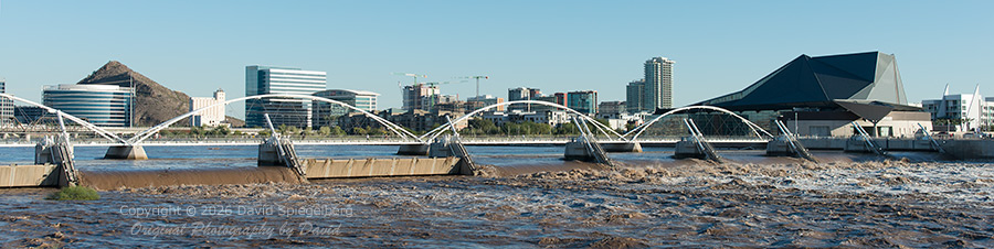
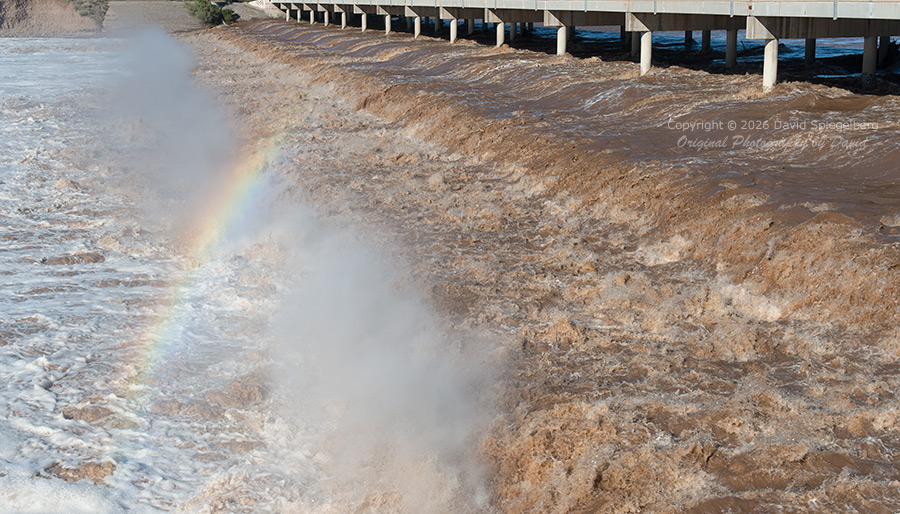
I was able to capture still images and video of the water flowing in the Salt River at two different locations: 1) Tempe Town Lake on November 2, and 2) Alma School Road on November 3.

The videos run over one minute and might take a short while to load. Click on the lower right icon to view full screen.

November 2, Tempe Town Lake (still image, wide view):

November 2, Tempe Town Lake (video):

November 3, Alma School Road (still image):

November 3, Alma School Road (video):

Posted on — Leave a comment

New Batch of Recently Photographed Prickly Pear Cactus Fruit and Firestick Cactus Images

FINE ART NATURE AND LANDSCAPE PHOTOGRAPHY OF ARIZONA, COLORADO, AND THE WESTERN UNITED STATES

In Arizona, Prickly Pear Cacti produce vibrant yellow and orange blossoms in the month of April. Like most cacti, the blossoms are only photogenic for the day on which they bloom because the hot sun causes the delicate petals to wilt.

By late August and into September, the Prickly Pear blossoms have morphed into fruit. If you catch them at just the right time, that fruit has a deep red color which makes for good photographs. Of course, it takes a cactus with a profuse April bloom (followed by a profuse amount of fruit later on) for the best photo opportunities.

I was able to find such a cactus, not in the wild but close to where I live, enabling me to get some really good photographs!

Another type of cactus, the Firestick Cactus, has been on my list of cacti to photograph for quite some time. If you live in the greater Phoenix area you’ve probably seen them when they turn a deep yellow/orange several times a year. If you’ve ever had the unfortunate experience of getting any of the juice/liquid in the cactus stems on your skin (or worse, in your eye), you know that it is very potent and can cause temporary blindness.

I was able to find some photogenic Firestick Cactus close to home which resulted in a few good photos.

Both the Prickly Pear fruit and Firestick Cactus images are included in this new batch of images, along with a bunch of others.

Here’s a list of the new images, all of which viewable on the New page:

  • Dead Cactus, Phoenix, Arizona (ID: 459)
  • Cirrus Cloud Formation, Phoenix, Arizona (ID: 463)
  • Dead Pine Tree, Phoenix, Arizona (ID: 458)
  • Firestick Cactus, Phoenix, Arizona (ID: 469)
  • Firestick Cactus, Phoenix, Arizona (ID: 470)
  • Fishhook Cactus Blossom, Phoenix, Arizona (ID: 464)
  • Prickly Pear Cactus Fruit, Phoenix, Arizona (ID: 452)
  • Prickly Pear Cactus Fruit, Phoenix, Arizona (ID: 455)
  • Red Push Pistache Tree Leaves, Phoenix, Arizona (ID: 460)
  • Red Push Pistache Tree Leaves, Phoenix, Arizona (ID: 461)
  • Prickly Pear Cactus Fruit, Arizona (ID: 451)
  • Prickly Pear Cactus Fruit, Arizona (ID: 454)
  • Echinopsis Cactus Blossoms, Arizona (ID: 457)
  • Firestick Cactus, Arizona (ID: 467)
  • Night-Blooming Cereus Cactus Blossom, Arizona (ID: 466)

Here are a few samples:

Posted on — Leave a comment

New Batch of Recently Photographed Aloe and Agave Images

FINE ART NATURE AND LANDSCAPE PHOTOGRAPHY OF ARIZONA, COLORADO, AND THE WESTERN UNITED STATES

In my early years of doing arts and crafts shows my signature image was “Beautiful Agave.” I discovered that image by chance. I was on an exploratory photography outing on Mingus Mountain in Arizona with nothing in particular in mind as far as subject matter. While driving to the top of the mountain I saw a rather large agave growing right near the side of the road. I stopped, backed up, got out of my vehicle and discovered a pristine, perfectly formed agave just begging to be photographed. As luck would have it, there was a rather thick layer of high clouds that morning which created the perfect highly-filtered light.

Ever since, I’ve been fascinated by the structure and beauty of agave and aloe plants but for whatever reason I haven’t had the opportunity to capture more images of them.

Agave and aloe plants are both succulents. The word “succulent” means juicy. Succulents are plants that store water in their tissues.

Visually, the plants look very similar, but there are distinct differences.

First, agave are generally larger than aloe and they have sharper, more rigid spines on the edges of the leaves.

Second, the inner leaves of agave are fibrous and durable, compared to aloe where the inner leaves are composed of gel.

Third, agave plants bloom only once in a lifetime, producing stalks up to 40 feet in height, after which the plants die. Aloe plants produce much smaller stalks (3-4 feet in height) and bloom year after year.

Fourth, agave plants have most of their growth in the warmer summer months then go partially or fully dormant in the winter. Aloe plants grow mostly in the cooler months of winter and then bloom in late winter or early spring.

In the greater Phoenix area, agave and aloe plants are used in both commercial and residential landscaping. You can also find them in great numbers in various succulent gardens (Desert Botanical Garden being the most prolific).

Here’s a list of the new agave and aloe images, all of which viewable on the New page:

  • Aloe Buds, Phoenix, Arizona (ID: 434)
  • Aloe Buds, Phoenix, Arizona (ID: 435)
  • Agave, Phoenix, Arizona (ID: 437)
  • Agave, Phoenix, Arizona (ID: 438)
  • Agave Flower Stalk, Phoenix, Arizona (ID: 440)
  • Aloe Blossoms, Phoenix, Arizona (ID: 434)
  • Aloe Blossoms, Phoenix, Arizona (ID: 443)
  • Aloe Blossoms, Phoenix, Arizona (ID: 445)
  • Agave Flower Stalk, Phoenix, Arizona (ID: 446)
  • Aloe Blossoms, Phoenix, Arizona (ID: 447)
  • Aloe Buds, Phoenix, Arizona (ID: 450)

Here are a few samples:

Posted on — Leave a comment

New Batch of Images from Existing Digital Inventory

FINE ART NATURE AND LANDSCAPE PHOTOGRAPHY OF ARIZONA, COLORADO, AND THE WESTERN UNITED STATES

I just completed work on a new batch of images from existing digital inventory. These images (12 in total) are now viewable on the New page.

Here’s a list of the new images:

  • Ocotillo Cactus Buds, Tonto National Forest, Arizona (ID: 423)
  • Waterfall, Apache Trail, Arizona (ID: 426)
  • Waterfall, Apache Trail, Arizona (ID: 427)
  • Queen Anne’s Lace, San Juan Mountains, Colorado (ID: 428)
  • Claret Cup Cactus Blossoms, Phoenix, Arizona (ID: 429)
  • Echinopsis Cactus Blossoms, Phoenix, Arizona (ID: 424)
  • Echinopsis Cactus Blossoms, Phoenix, Arizona (ID: 424bw)
  • Echinopsis Cactus Blossoms, Phoenix, Arizona (ID: 425)
  • Waterfall, San Juan Mountains, Colorado (ID: 432)
  • Red Bird of Paradise Blossoms, Phoenix, Arizona (ID: 431)
  • Common Chuckwalla, Phoenix, Arizona (ID: 422)
  • Raindrops on Corn Lily, San Juan Mountains, Colorado (ID: 442)

Here are a few samples:

Posted on — Leave a comment

Second New Batch of Images from Existing Film-Based Inventory

FINE ART NATURE AND LANDSCAPE PHOTOGRAPHY OF ARIZONA, COLORADO, AND THE WESTERN UNITED STATES

I just completed work on a second new batch of images from existing film-based inventory. These images (14 in total) are now viewable on the New page.

To identify and select these 14 images I spent a long, long time going through all of my previous 35mm and 4×5 work, one transparency at a time. I can now say I have ALL of my best work viewable on my website!

In case you are wondering, I had all of these transparencies scanned by Bay Photo in California. They use a “Heidelberg Tango” drum scanner which is, arguably, the best film scanner available. 35mm images were scanned to a file size of 200mb, and 4×5 images were scanned to a file size of 600mb.

Here’s a list of the new images:

  • Superstition Mountains Glow, Tonto National Forest, Arizona (ID: 402)
  • Frost on Corn Lilies, Yosemite National Park, California (ID: 405)
  • Ophir Needles (Autumn), San Juan Mountains, Colorado (ID: 406)
  • Raindrops on Bluebells and Corn Lilies, San Juan Mountains, Colorado (ID: 407)
  • Glowing Thundercloud, Tonto National Forest, Arizona (ID: 410)
  • Fishhook Cactus Blossoms, San Manuel, Arizona (ID: 411)
  • Fishhook Cactus Blossoms, San Manuel, Arizona (ID: 413)
  • Waterfall, San Juan Mountains, Colorado (ID: 414)
  • Lower Antelope Canyon, Page, Arizona (ID: 415)
  • Waterfall, San Juan Mountains, Colorado (ID: 417)
  • Queen Anne’s Lace, San Juan Mountains, Colorado (ID: 419)
  • Waterfall, Apache Trail, Arizona (ID: 420)
  • Shale Rock Formation, San Juan Mountains, Colorado (ID: 421)
  • Claret Cup Cactus Blossoms, Prescott National Forest, Arizona (ID: 416)

Here are a few samples:

Posted on — Leave a comment

New Batch of Images from Existing Film-Based Inventory

FINE ART NATURE AND LANDSCAPE PHOTOGRAPHY OF ARIZONA, COLORADO, AND THE WESTERN UNITED STATES

I just completed work on a new batch of seven images from existing film-based inventory. Those images are now viewable on the New page.

Here’s a list of the new images:

  • Buckhorn Cholla Cactus Blossoms, Tonto National Forest, Arizona (ID: 399)
  • Buckhorn Cholla Cactus Blossoms, Tonto National Forest, Arizona (ID: 027)
  • Grand Canyon Storm Clouds, Yapapai Point, Arizona (ID: 050-141)
  • Fall Aspen (Rowdy Lake), Uncompahgre National Forest, Colorado (ID: 032-133)
  • Three-Tier Waterfall, San Juan Mountains, Colorado (ID: 275)
  • Wildflowers, San Juan Mountains, Colorado (ID: 279)
  • Wildflowers, San Juan Mountains, Colorado (ID: 274)

To follow up on my previous post, you can now view my computer illustrations on the Misc page.

Posted on — Leave a comment

Original Photography by David Version 2.0

FINE ART NATURE AND LANDSCAPE PHOTOGRAPHY OF ARIZONA, COLORADO, AND THE WESTERN UNITED STATES

After a lengthy and arduous website rebuild, Original Photography by David version 2.0 is finally up and running!

Improvements and highlights include:

  • Improved website rendering on all devices regardless of screen width
  • Built with the WordPress content management system (the previous platform was OpenCart)
  • Employs the WooCommerce plugin (which provides all e-commerce functions)
  • Simplified purchase options (now, I sell only prints on the website, but finished work is still available by contacting me via my Contact page)
  • A very similar look and feel to my previous website (with dark page backgrounds to make images stand out)
  • Two new multi-image slides on the Home page showcasing Arizona Flora and Colorado Flora
  • Image titles shown on image category/thumbnail pages
  • Revised and updated About page text
  • New Black and White category with two images (more to come)
  • Fourteen new digital images shot over the past year (click on samples below)

Two other tasks are currently in progress:

First, soon I will have a handful of computer illustrations I created a number of years ago with Adobe Illustrator displayed on my website.

Second, I am in the process of going through my entire inventory of film-based images (both 35mm and 4×5). During my review, I’m selecting all images I think have potential “merit” to display and sell on my website. It’s a slow process, and all images I want to display will have to be digitally scanned (some at very high-resolution and cost). The end result will be small batches of new images (shot many years ago) added over the next several years, and the satisfaction of knowing I’m showing ALL of my best film-based work, going all the way back to 1990!